Past event — This event ended 21 days ago.
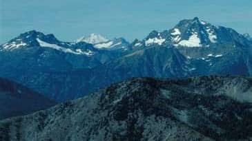
Pasayten Wilderness Mega Traverse Expedition
About the event
🏔️ Pasayten Wilderness Mega Traverse Expedition
Mount Rolo → Osceola → Carru → Lago → Dot → Ptarmigan → Blackcap → Pass Butte → Lost → Johnny → Many Trails
Duration: 4 Days / 3 Nights Season: Early June 2026 (Very Low Snow Year) Style: Backpacking + Peakbagging Traverse Difficulty: Advanced Wilderness Mountaineering Technical Difficulty: Mostly Class 2, occasional Class 3 route finding Total Distance: ~50–60 miles Total Elevation Gain: ~18,000–22,000 ft Bulgers: 6/100
⸻
🎯 Expedition Objective
Complete one of the premier peakbagging traverses in the Pasayten Wilderness, linking:
1. Mount Rolo 🌟 1. Osceola Peak ⭐ 1. Mount Carru ⭐ 1. Mount Lago ⭐ 1. Dot Mountain 🌟 1. Ptarmigan Peak ⭐ 1. Blackcap Mountain ⭐ 1. Pass Butte 🌟 1. Lost Peak ⭐ 1. Johnny Peak 🌟 1. Many Trails Peak 🌟
⭐ = Bulger Peak 🌟 = Top 200
⸻
🚗 Travel Logistics
Thursday Evening
Drive from Seattle to the Pasayten.
Approximate drive:
Seattle → Winthrop → Loomis → Slate Peak Road
Distance: ~280 miles
Time: ~6.5 hours
Recommended:
✅ Sleep at trailhead
or
✅ Car camp near Iron Gate
Early start is critical.
⸻
🗺️ Route Overview
The traverse naturally breaks into:
Phase 1
Northern Okanogan Range
• Rolo • Osceola • Carru
Phase 2
Lago Basin
• Lago • Dot
Phase 3
Central Crest
• Ptarmigan • Blackcap • Pass Butte
Phase 4
Southern Peaks
• Lost • Johnny • Many Trails
⸻
DAY 1
Iron Gate → Rolo → Osceola → Carru
Camp: Carru Basin
🥾 Distance: ~13 miles
⬆️ Gain: ~5,500 ft
⸻
Start
Leave trailhead:
5:00 AM
Follow the Boundary Trail south.
⸻
🏔️ Mount Rolo
Class 2
Easy tundra slopes.
Roundtrip off-route: ~1 mile
⸻
🏔️ Osceola Peak ⭐
Class 2
One of the finest summits in the Okanogan Range.
Outstanding views toward:
• Lago • Carru • Cathedral Group
Allow: 1.5 hours
⸻
🏔️ Mount Carru ⭐
Class 2
Continue south via broad ridge.
This is straightforward in low-snow conditions.
⸻
🏕️ Camp 1
Carru Basin
Why camp here:
✅ Reliable water
✅ Beautiful scenery
✅ Excellent positioning for Lago
✅ Protected from wind
Elevation: ~7,000 ft
Expected arrival: 5–7 PM
⸻
DAY 2
Carru Basin → Lago → Dot → Ptarmigan
Camp: Ptarmigan Basin
🥾 Distance: ~11 miles
⬆️ Gain: ~4,000 ft
⸻
🏔️ Mount Lago ⭐
Class 2
Highest summit of the trip.
One of Washington’s great Bulgers.
Allow:
2–3 hours from camp.
⸻
🏔️ Dot Mountain
Class 2
Quick bonus summit.
Minimal extra effort.
⸻
🏔️ Ptarmigan Peak ⭐
Class 2
Long scenic ridge travel.
Some talus.
No major difficulties expected in a low snow year.
⸻
🏕️ Camp 2
Ptarmigan Basin
Excellent water.
Excellent sunset.
Ideal launch point for Blackcap.
Elevation: ~6,800–7,000 ft
Arrival: 4–6 PM
⸻
DAY 3
Ptarmigan → Blackcap → Pass Butte → Lost
Camp: Lost Creek Basin
🥾 Distance: ~12–14 miles
⬆️ Gain: ~5,000 ft
⸻
🏔️ Blackcap Mountain ⭐
Class 2–3
One of the best viewpoints in the Pasayten.
Short scrambling near summit.
⸻
🏔️ Pass Butte
Class 2
Easy summit.
Fast ascent.
⸻
🏔️ Lost Peak ⭐
Class 2–3
Perhaps the most rugged mountain on the route.
Excellent views.
Some loose terrain.
Take your time.
⸻
🏕️ Camp 3
Lost Creek Basin
Reliable water.
Protected campsites.
Excellent positioning for final day.
Arrival: 5–7 PM
⸻
DAY 4
Johnny → Many Trails → Exit
🥾 Distance: ~15–18 miles
⬆️ Gain: ~3,000 ft
⬇️ Loss: ~6,000+ ft
⸻
🏔️ Johnny Peak
Class 2
Quick summit.
Mostly tundra.
⸻
🏔️ Many Trails Peak
Class 2
Final summit.
Excellent finale to the traverse.
⸻
Exit
Follow trail system northward back toward Iron Gate.
Expected trailhead arrival:
4–8 PM
depending on pace.
⸻
💧 Water Strategy
Low snow year means many seasonal streams may already be drying.
Reliable sources:
✅ Carru Basin
✅ Lago Basin
✅ Ptarmigan Basin
✅ Lost Creek Basin
Always leave camp with:
2–3 liters
Do not assume ridge water.
⸻
⚠️ Major Hazards
Heat
Likely your biggest challenge.
Expect:
70–85°F afternoons
Little shade.
⸻
Navigation
Much of the traverse is off-trail.
Bring:
• Gaia…